Airfield Pavement Management

Managing airfield pavements is complex, requiring precision and a deep understanding of aviation standards. Our team offers comprehensive airfield pavement management solutions that help you maintain safe and cost-effective operations. Our integrated services ensure your runways and taxiways remain in optimal condition year-round. We bring a full spectrum of services under one roof, providing a holistic approach to airfield pavement management. Here’s what sets us apart:

Airfield High-Resolution Imaging

Our advanced imaging technology captures detailed, accurate data, empowering you to make informed decisions about maintenance and rehabilitation. High-resolution imaging allows us to identify even the most minor defects, ensuring your airfield remains safe and compliant with aviation standards.

Surveys are performed with an IrisPRO Pave™ data collection system. The IrisPRO Pave™ collects georeferenced, high-resolution 3D imagery of the pavement surface, spherical right-of-way imagery, and longitudinal and transverse profile measurements. The artificial laser illumination emitted by the LCMS-2 ensures constant, consistent imagery under ambient lighting conditions. The images below were collected at night, making the LCMS-2 technology the most effective for capturing imagery at commercial airports.
Airfield High-Resolution Imaging
Example 3D LCMS-2 Imagery of Concrete Apron Pavements with Pavement Distresses Identified.

Airfield Distress Surveys

We identify and quantify pavement distress through thorough inspections, helping you develop an effective preservation strategy. Our distress surveys are meticulously conducted to assess the condition of your pavements, providing you with a clear understanding of the current state and any necessary interventions. Collected data are processed to quantify pavement surface distresses’ type, severity, and quantity, including cracking and rutting. Airfield distresses and Pavement Condition Index (PCI) are reported following a modified ASTM D5340 standard.

High-Quality Data for Defensible Planning

Using high-quality data, we enable defensible long-term plans that reduce downtime and extend pavement lifespan. Our tailored management plans are designed to meet the unique needs of your airfield, incorporating the latest technologies and methodologies to ensure the most efficient and effective maintenance schedules.

Our unique stitching process ensures the delivery of 100% of the pavement data, with no duplicate distresses, providing the most accurate LCMS data. This process allows us to stitch together all the pavement images, removing any areas of overlap while creating a georeferenced GIS layer of high-resolution images of the surveyed data. This output can be readily used in any GIS software, such as ArcMap, QGIS, etc.

Stitched Anchor Points
Example of stitched images with stitching anchor points
LCMS-2 Imagery of concrete apron pavements with pavement distresses identified

Teaming With Aviation Experts

While we have a team of highly skilled pavement engineering consultants, we often team with civil engineering firms with dedicated practices in aviation pavement management, bringing them our high-quality data and deliverables to enhance decision-making and planning for the end users/owners.

Regulatory Compliance

Staying compliant with aviation regulations is crucial for airfield operations. Our solutions are designed to ensure that your pavements meet all necessary regulatory standards, providing peace of mind and helping you avoid costly penalties or operational disruptions.

Cost-Effective Solutions

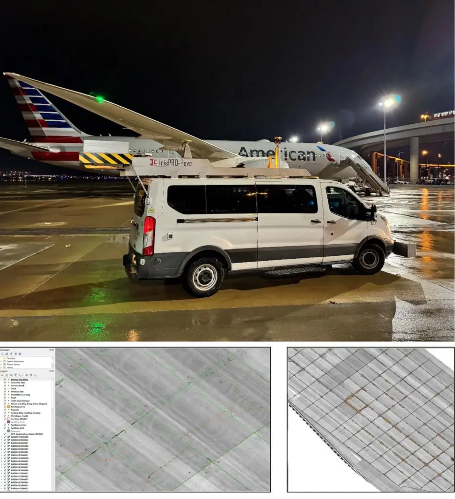
We understand the importance of cost efficiency in maintaining airfield pavements. Our services are designed to provide maximum value, helping you minimize costs while maintaining high safety and performance standards. By collecting pavement condition data faster than manual surveys and at night, operational disruptions are kept to a minimum. Our high-quality data also gives owners the confidence that the right rehabilitation decisions are being made. Last, our accurate and repeatable data collection and processing approach allows for unmatched distress comparison capabilities when separate survey cycles are performed (e.g., years later).

Simplified Deliverables with High-Quality Data

While our data collection and processing methods utilize sophisticated, industry-leading technology operated and processed by our team of experts, our deliverables are yours to own and use easily. Our typical deliverables include:

• The surveyed area is mapped with high-quality images.

• Shapefiles for each distress are fully compatible with any GIS software, with no need for proprietary tools, meaning you can use the data flexibly across platforms like ArcMap and QGIS.

• Raster images stitched and tied down to the slab and sections of the GIS layer provided by the client.

Let’s simplify your airfield pavement management process

Contact us to see how we can combine these services for maximum efficiency. With ICC-IMS, you can trust that your airfield pavements are in expert hands, ensuring safety, performance, and cost-effectiveness.
Our clients